Ozark Township | |
|---|---|
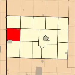 Location in Barton County | |
| Coordinates: 37°33′09″N 094°32′00″W / 37.55250°N 94.53333°W | |
| Country | United States |
| State | Missouri |
| County | Barton |
| Area | |
| • Total | 38.55 sq mi (99.84 km2) |
| • Land | 38.36 sq mi (99.35 km2) |
| • Water | 0.19 sq mi (0.5 km2) 0.5% |
| Elevation | 889 ft (271 m) |
| Population (2000) | |
| • Total | 1,102 |
| • Density | 28.7/sq mi (11.1/km2) |
| GNIS feature ID | 0766285 |
Ozark Township is a township in Barton County, Missouri, USA. As of the 2000 census, its population was 1,102.
The township takes its name from the Ozark Mountains.[1]
Geography
Ozark Township covers an area of 38.55 square miles (99.8 km2) and contains two incorporated settlements: Burgess and Liberal. According to the USGS, it contains two cemeteries: Liberal and Yale.
The streams of East Drywood Creek, Fleck Creek and Second Nicolson Creek run through this township.
References
- ↑ "Barton County Place Names, 1928-1945 (archived)". The State Historical Society of Missouri. Archived from the original on June 24, 2016. Retrieved August 31, 2016.
{{cite web}}: CS1 maint: bot: original URL status unknown (link)
External links
Municipalities and communities of Barton County, Missouri, United States | ||
|---|---|---|
| Cities | 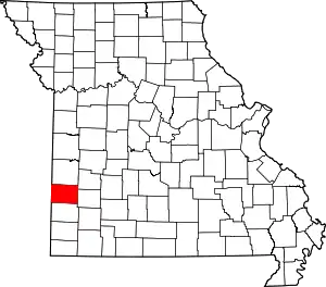 Map of Missouri highlighting Barton County | |
| Villages | ||
| Townships | ||
| CDPs | ||
| Other communities | ||
| Ghost towns | ||
This article is issued from Wikipedia. The text is licensed under Creative Commons - Attribution - Sharealike. Additional terms may apply for the media files.